
Spatial Computing Report: The Anatomy of the Hurricane and Nor’easter

Executive Abstract
In this report, a comparison has been made between two types of storms using a paired case study that took place in September 2026. The two storms are Hurricane Polo from the Eastern Pacific, which is a Category 5 storm, and the Mid-Atlantic/Long Island nor’easter. Though both storms belong to the same family of cyclonic low-pressure formations, the two storms operate completely differently. The hurricanes are powered by warm-core heat engines that operate based on the theory of the maximum potential intensity, whereby energy from the ocean surface is collected by hurricanes. Nor’easters, on the other hand are powered by cold-core baroclinic systems, which get energy from keeping a temperature difference around the storm while travelling at the mid-latitudes.
While analyzing the behavior of Polo, it has been observed that this storm experienced rapid intensification. The winds reached 180 mph while the air pressure dropped by 90 mb within 24 hours due to unusually warm ocean water (temperature of 32 degrees). The nor’easter, on the other hand, followed a traditional way of bomb-cyclogenesis, which allowed it to build an enormous wind field as well as some erosion at the coast.
Indeed, hurricanes and nor’easters are both cyclones, but they arise from different engine designs. This report will examine their opposite structures using the examples of two storms in September 2026—Hurricane Polo and the East Coast nor’easter (it will pay particular attention to the changing oceans and jet streams).
The comparative analysis presented in the report illustrates the opposite categories of systems: compact/symmetric vs broad/asymmetric and short-term intense surge vs long-term multiple-tide onslaught. There is also attention paid to the boundary zone (extratropical transition and warm seclusion), indicating these are not strict dichotomies.
In conclusion, the report concludes both devices in terms of their contribution to climate change: as the ocean warms, the intensity of hurricanes increases; while Arctic amplification may lead to weakening and destabilization of the jet stream, thus favoring the trough-hooking that results in dangerous nor’easters. The rising sea level might increase the effect of both.
Introduction: Two Cyclones, Two Engines
There are few phenomena that bring to light the working mechanism of the atmosphere as the cyclone does. In essence, the low-pressure rotating vortex is simply a mechanism to convert a reservoir of energy into organized wind. A unique feature of studying storms is that there are two widely different versions of the same object in the atmosphere. The tropical cyclone, also known as the hurricane, is a heat engine that uses the heat from the ocean surface, whereas the extratropical cyclone, e.g., the nor’easter in North America, is a cold-core baroclinic wave that utilizes temperature differences in the mid-latitude westerlies (Holton & Hakim, 2012; Schultz et al., 1998). They are both spinning, they both deepen, and they both create floods, but their origins are almost opposite.
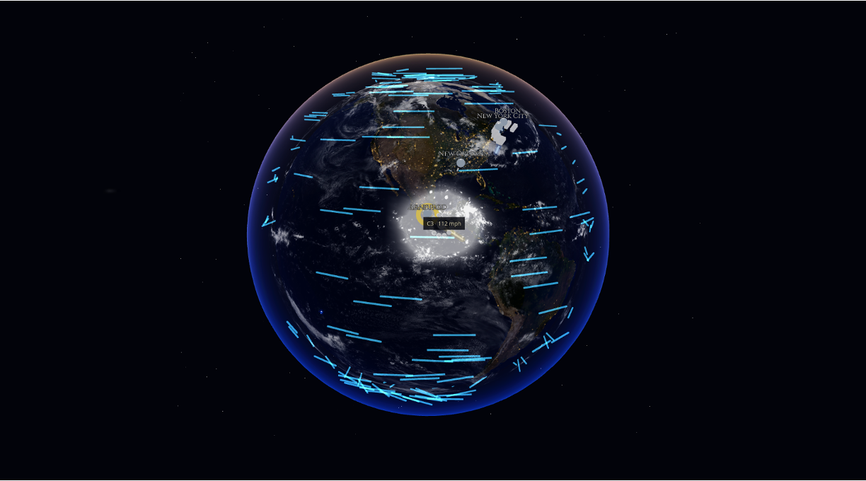
September 2026 offered an unusual pair of phenomena. In the Eastern Pacific Ocean, Hurricane Polo underwent explosive rapid intensification to 90 knots of wind in just a day and became a Category 5 hurricane over the water with a temperature of 32 degrees Celsius. Later, while the Mid-Atlantic and Long Island were experiencing coastal low pressure or bomb cyclone deepening, an upper-level trough aligned with a southern frontal cyclone. The two storms are the natural anchors of this dissection: one a portrait of oceanic thermodynamics, the other of atmospheric dynamics.
The thesis of this report can be boiled down to this simple concept. The phenomena of hurricanes and nor’easters represent the same fluid dynamics modelled by the same equations, but there exists a difference between them in terms of energy source and mechanism—either the latent heat emanated from the warm ocean or the potential energy available in the temperature difference of the fluid. A key to understanding their structure, forecasting their future behavior, and predicting the implications of climate change is the understanding of this difference (Knutson et al., 2019; IPCC, 2021).
A note on methodology: As tropical cyclones are inherently three-dimensional entities that evolve in the course of time, the essay is built upon a variety of media, including narratives, equations, and satellite images, as well as statistical matrices. Studies show that the use of different types of representations improves understanding, and the use of a multi-modal approach has established its efficiency in the field of Earth sciences (Ainsworth, 2006; Dede, 2009; Shelton & Hedley, 2002).
The Twin Engines: Latent Enthalpy versus Baroclinic Shear
The mechanism behind hurricanes is thermodynamic in nature. In Kerry Emanuel’s air-sea interaction theory, tropical cyclones are explained as applying a Carnot cycle since the air enters the ocean, getting energy in the form of enthalpy, both sensible heat and, therefore, critical latent heat from the ocean. Then, the air rises in the eyewall, releasing energy in the form of radiation cooling, thus moving down in the environment (Emanuel, 1986). As a result, as the efficiency of heat engines correlates directly with the temperature of the area where the air enters the machinery, the strength of the cyclone is determined by how different the temperature of the hot ocean surface is from that of the cool atmosphere above.
This is called the maximum potential intensity, which is the reason why one needs to be particularly attentive to the temperature of the sea surface and its importance in forecasting hurricanes. The warm ocean increases the efficiency of the process as well as the amount of energy (Sobel et al., 2016). Previous studies explained this as a process of creating a cyclone due to frictional convergence in the vortex system, which concentrates humidity, encourages convection, and reduces the pressure at the cyclone center, thus strengthening the flow of air (Charney & Eliassen, 1964).
The nor’easter is driven by an altogether different energy source than the one used by hurricanes. Extratropical cyclones are cold-core systems whose growth takes place through baroclinic instability, or the process of transformation of the potential energy in the form of temperature and density differences between polar and subtropical air masses (Holton & Hakim, 2012). While hurricanes require a vertical column of air such as warm over warm, nor’easters are reliant on horizontal conditions; that is, heat difference is required to exist under the jet stream. The thermal wind equation is the governing theory due to the relationship between the vertical shear of wind and temperature gradient.
The thermal wind theory dictates that vertical shear of geostrophic wind is directly related to horizontal temperature difference (Holton and Hakim, 2012). Thus, a significant horizontal temperature difference means that there is a strong jet stream above and that instability of the jet—its bending into waves—leads to the formation of surface lows. The mechanism can easily be explained through the potential vorticity concept: when there is a pressure-volume anomaly aloft (for example, a dip in the tropopause), it causes cyclonic circulation to form below, and when this effect coincides with a warm patch above a low-level warm area, those two systems are capable of self-amplification (Davis & Emanuel, 1991). In brief, the only way for a hurricane to develop is to happen through the process of rising from the ocean, while the nor’easter develops downwards from the jet.
Both feedback mechanisms work in practice, and their respective significance helps to explain the difference between some of the tropical depressions that come to a standstill, while others like Polo move to their full strength almost instantly after the shear effects are diminished. The same logic holds for extratropical processes: not every trough produces a bomb, as it is important that upper- and lower-level phenomena are connected to one another in the correct positions and time (Sanders & Gyakum, 1980).
Case Study: Hurricane Polo
Hurricane Polo was created in the Eastern Pacific Ocean in September 2026. This hurricane should be seen as a model of a cyclone capable of showing explosive rapid intensification, and it may even set a record. According to the operational definitions, rapid intensification is defined as an increase of 30 knots in 24 hours or more. Polo officially participated in rapid intensification and roughly tripled that figure, reaching Category 5 intensity after an increase of nearly 90 knots within 24 hours. The researchers, including Stern, believed that the phenomena that fall into the rapid intensification category are different from regular rapid intensification events and thus classified as extreme RI events and responsible for most unexpected outcomes of landfall.
The specifics of the ocean made the phenomenon possible. Sea surface temperature under the path of Polo reached around 32°C. The temperature is regarded as significantly higher than the climatological averages for the area, which was critical, as this temperature was maintained over a deep layer of water, and thus large ocean heat content accumulated under the storm when upwelling occurred. At a higher level of the MPI theory, deeper and warmer water increases both Carnot efficiency and enthalpy supply while limiting the effects of negative feedback from the cold upwelling of water caused by the storm (Emanuel, 1986; Sobel et al., 2016).
As the vortex grew stronger, its central pressure lowered to about 892 mb, and maximum sustained winds reached near 180 mph. The eyewall created a ring of strong convection around a warm and clear eye, which led to rising temperatures aloft, a signature of a highly developed warm-core system. If one stood in the eyewall, he or she would experience a very steep pressure difference and would observe winds of 180 mph, while radial flow was still weak. Both Tier 1 reporting and satellites emphasized how quickly the storm.
Polo is another example of internal forces that allowed achieving rapid strengthening. Intensifying hurricanes typically undergo a process called the eyewall replacement cycle, during which the outer convection ring retracts and suffocates the inner eyewall, stopping deepening for a while and bringing about the development of a new, sometimes more powerful, eyewall. Vertical wind shear, dry air intrusions, and cold wakes are typical reasons why the process occurs; however, due to the deep warm layer, the cold wake was absent in Polo’s case, and the low-shear condition prevented any ventilation of the warm core.
Polo showcases why rapid intensification is one of the major challenges faced by operational meteorologists. Minor inaccuracies in calculating ocean heat content, mid-level humidity, or the timing of an eyewall reconstruction can result in the difference between a Category 2 and a Category 5 hurricane and leave coastal residents little time to respond. For a long time, the Eastern Pacific region has been one of the most preferred areas for such developments since the warm pool is situated very close to the shore. According to Polo, the real-time technique was able to signal the presence of unusual subsurface warmth below the storm before the central pressure had dropped, which was an early indicator of the change in intensity.
Case Study: The East Coast Fall Nor’easter
The nor’easter that occurred in September 2026 was a naturally occurring phenomenon. Originally, this storm system set out as a coastal low moving in the direction of Long Island but came to form due to cyclonic development through the interaction between the southern jet stream, originating from the Gulf of Mexico, and the heavy cold air coming from the north, brought by the upper-level trough system, coming from the Great Lakes area. The way these two systems cooperate is known as phasing and is a typical element of northeast storms (Kocin & Uccellini, 2004).
Uccellini & Kocin believe that the strongest coastal cyclogenesis happens when jet streaks move together. A “perfect setup” occurs when the “diffluent left exit” of one of the jet streams coincides with the “right entrance” of another jet stream in such a way that upper-level divergence is combined over the surface low-pressure area (Uccellini & Kocin, 1987). Such divergence will remove mass from the air column; this will lead to a decrease in surface pressure and an increase in low-level convergence and frontogenesis at the coast—the same subsynaptic mechanism was noticed by Bosart in relation to the Presidents’ Day storm (Bosart, 1981). A more theoretical approach based on the analysis of the potential vorticity gives another explanation for this event—there is only a simple synergy of the upper trough and the low-level baroclinic zone at work in the system (Davis & Emanuel, 1991).
When the central pressure of a depression drops more than the Sanders–Gyakum threshold—geostrophically 24 mb within 24 hours—it becomes a “bomb,” and this nor’easter qualified as the pressure dropped to around 958 mb (Sanders & Gyakum, 1980). The release of latent heat associated with the warm conveyor belt, which caused the intensification, aided the system as well, just as it was during the development of Gyakum’s famous QE II storm, thus softening the boundaries between dynamic and thermodynamic effects (Gyakum, 1983).
The experience of the storm was lived out somewhere along the coast. Instead of the typical compact eyewall, the cyclone produced an extensive comma-shaped cloud shield with a large area of gale-force winds at the northern and eastern edges of the system. The prolonged steady onshore winds created a long fetch, resulting in the formation of large waves and an increase in water levels; the continuity of this wind field (which caused the surf to continue pounding the shore at the same time as the tides were high) resulted in significant erosion and scarping of the beaches on the exposed barrier coast. Thus, one must see the storm as a multilayered phenomenon that encompasses the atmospheric pressure field at high altitudes, the wind field at the surface, and, at the coast, areas of wave height and erosion that these winds created (MacEachren & Kraak, 2001).
The geographical features of the coast also played a role. The Appalachians blocked the cold air, and the thermal disparity between the land and sea created a coastal front where the low caught the precipitation and enhanced the baroclinicity at the low levels (Bosart, 1981). The difference between the nor’easter and a hurricane is that the danger from the former is cumulative. Nor’easters carry strong winds over long distances, and water piles up along the shores through several high tides, causing the problem of beach erosion and tidal flooding over a long period of time (Kocin & Uccellini, 2004).
Comparative Anatomy: Warm Cores and Cold Shields
A comparative assessment of the two systems demonstrates the differences in their anatomy. The hurricane is relatively small and symmetrical and is a vertical system with a warm core intensifying with altitude, a small radius of maximum winds, spiral rainbands feeding into a well-defined eye, and an inflow layer that is shallow, topped by a capital anti-cyclone outflow system. On the other hand, the nor’easter system is relatively large and asymmetric and is slanted in nature with a cold core, a comma-shaped cloud shield, sharp frontal boundaries separating different air masses, and the maximum wind well away from the center of the system.
Thermal Energy and Dynamic Mechanisms
There are many ways in which hurricanes obtain their energy, with most of it being derived from warm ocean surfaces because of air-sea imbalance and transfers of heat via wind and convection processes. In contrast, the energy source for Nor’easters is represented by the potential energy trapped in horizontal temperature differentials, with a specific association between the western trough and jet streaks indicating the start of cataclysmic development near the coastal front.
Natural Phenomenon Characteristics
First, hurricanes consist of a warm-core symmetric structure and possess an intensity that increases with height. Secondly, hurricanes exhibit compact wind fields, implying high wind speeds and a small radius of maximum wind surrounding their central point. However, in the case of nor’easters, cold-core asymmetric circulation takes place even though identifiable warm pockets can also be formed along the way; their structure tells us that wind fields of nor’easters are considerably larger and a lot of strong wind events take place deep away from the central point of low pressure.
Cloud formations
As to the visual appearance of hurricanes, they are understood as those possessing well-developed spiral bands and eye-shaped patterns of cloud formation. There is also a pattern of development for Nor’easters, on the contrary, characterized by the presence of comma-shaped cloud shields. It should be mentioned that differences in the structures and characteristics of these two types dictate the timing of hurricanes (they are mostly formed during the warm season, such as in the case of Hurricane Polo for the Eastern Pacific) and nor’easters (which mostly take place during the cold season along mid-latitudes).
The source of energy is dictated by that geometry. A hurricane relies mostly on its energy reserve located in the ocean below, which explains the sudden weakness of hurricanes upon their contact with land. However, a nor’easter takes advantage of the huge temperature difference between the autumn continental masses and the warm waters of the Gulf Stream, which allows it to exist as long as the difference of temperature and the upper jet stream are there (Kocin & Uccellini, 2004). The coastal dangers are not the same for the two phenomena: the hurricane creates a violent but short surge flow, while the nor’easter produces a somewhat milder but continuous attack of wind, waves, and erosion throughout several tide cycles.
One of the major distinctions apparent between hurricanes and nor’easters lies in the scale and the duration of the events. The highly destructive vortex of a hurricane is only a few tens of kilometers wide but can reach its full strength in mere hours, whereas a mature nor’easter could have its hurricane-force winds spanning hundreds of kilometers across and lasting for days or longer as it slowly moves northeast along the coast (Schultz et al., 1998). This difference is not accidental. Rather, it emanates from where they get their energy. A point-like source of energy provided by the warm sea under the eye produces a narrow but highly intense vortex, while a distributed source such as a long continental temperature front can produce a distant but long-lasting phenomenon that replaces high wind speeds with great persistence and coverage.
The Boundary Zone: Extratropical Transition and Hybrids
The neat distinction between the two categories of weather systems becomes less clear in transition zones, as storms can switch from one type of system to another. The extratropical transition refers to the process whereby a tropical cyclone moves polewards into the zone of baroclinic westerlies. During this transition, the warm core of the system erodes while the wind field expands and changes from being circular in nature to having fronts due to utilizing the horizontal temperature gradient for further development (Shultz et al., 1998).
The Shapiro-Keyser model of frontal cyclones has another aspect that can be applicable to storms: the phenomenon known as the warm-seclusion process, which entails wrapping up a pocket of warm air, thus yielding the low central pressure and creating a warm core of the cyclone (Shultz et al., 1998). The mixing is complicated by the feedback effects coming from the potential vorticity and release of latent heat during the transition period, implying that storms like QE II and numerous Atlantic bombs should be viewed as dynamically created systems using thermodynamic effects if necessary (Gyakum, 1983; Davis & Emanuel, 1991).
The above implications can be translated into a practical application. Indeed, during the transition process, the storm can increase the size or extend the wind field by reducing the maximum wind speed and, consequently, create a wider area of destruction (Schultz et al., 1998; Kocin & Uccellini, 2004). Thus, the forecasters are inclined to look for the signs of hybrid weather systems and monitor the development of the related processes (Schultz et al., 1998).
A Warming Ocean, a Shifting Jet, and the Road Ahead
The warming climate retunes both systems differently. The warming of the ocean increases the upper limit of the possible strength of storms, and indeed the record states that the most powerful storms get stronger the fastest: The Power Dissipation Index of Emanuel has increased together with the increase of water surface temperature in the tropics, while Elsner et al. showed the upper quantiles moving upwards fairly steeply (Emanuel, 2005; Elsner et al., 2008). The AR6 assessment and the report by the WMO experts say that there are quite a few reasons to assume that the number of Category 4-5 storms is increasing, as well as cases of rapid increases in strength; besides, people are known to leave their trace in physics (IPCC, 2021; Knutson et al., 2019; Sobel et al., 2016). What Polo states about his 32°C warm layer is exactly what those studies reveal.
Rainfall behaves according to the same thermodynamic principles. The warmer the atmosphere, the more moisture it can hold, as it is believed that for each degree Celsius the air may hold around 7% more water vapor (Trenberth, 2011). The phenomenon becomes much stronger when the systems start stopping or slowing down and let it rain on the same ground for a more extended period.
At the same time, however, the mechanisms of the extratropical organism operate due to the actions of the jet stream. The reduction of the temperature gradient between the north and south poles of the planet makes the jet stream slack and buckle (Francis & Vavrus, 2012; Cohen et al., 2014). The response is disputable and seems to run through several stages. As to Overland et al. (2016) it seems as if a wavier jet stream has its pros.
The storms of September 2026 then serve as examples of both how certain weather mechanisms function and hints of what is yet to come. Hurricane Polo provides insight into what happens when heat accumulates in the ocean, as well as how hybridized tropical weather combines forces with the jet stream to give rise to new dimensions and forms of the baroclinic engine on the US East Coast. Examining these storms together enables one to see how different forms of weather work and find essential information that is needed to prepare for the next storms (Knutson et al., 2019; IPCC, 2021).
The type of interaction between these two weather systems only intensifies, and new opportunities for devastation appear. The rise in sea levels raises the underlying sea levels from which any surge of a hurricane or a tide of a nor’easter can emerge, which means that storms with the same weather characteristics cause damage deeper inland as well (IPCC, 2021). When the jet stream slows down and creates waves, or when bomb cyclones drop rain on already eroding shores, it can cause flooding that is far worse than what is predictable based on the wind or rain alone (Trenberth, 2011; Rahmstorf et al., 2015). The examination of these storms becomes an important tool to devise effective coastal adaptation mechanisms that will be required in the future.